Showing posts with label nature. Show all posts

1/06/2020

Memorable Khokana to Champadevi Hike


Winter is the great season to go out for a hike around Kathmandu valley. One can escape the chaos of the city once in a while when one can enjoy lush jungles, adventurous trails and beautiful view of the Himalayan ranges in the north.
On 11 December 2019, six members from KIAS set for a hike to Champadevi peak at around 8:30 am from Khokana Bus Park which is 4 km south from Ekantakuna, Lalitpur. We were to follow our route from Khokana-Pharping-Bhanjyang to Champadevi and finally to Machhegaun. Khokana is a traditional Newari town of Lalitpur which is known for its mustard oil. On the way, we passed by Shree Rudrayani temple which is said to made by King Amara Malla in the 15thcentury, around which Khokana is believed to come into existence.


Under the warm early morning sun, we walked through paddy fields where straw was left for drying. Ahead was a suspension bridge and River Bagmati that looked awful and carried foul smell. It is so disheartening to see our river turn into no less than a sewer. Walking alongside Bagmati river corridor, we could see tunnel farming for off-season vegetables and mushrooms being done and also brick kilns. After an hour walk we reached the Pharping Hydropower Station, also known as Chandra Jyoti Hydro-electric Power Station established in 1911 AD. It is the first hydropower project of Nepal and the second oldest in Asia. We went on to have a look inside the station, which surprisingly is still in operation but restricted to few hours a day. 

Our team then followed stairs alongside the penstock pipe of the project upwards to the reservoir, which now supplies drinking water for Lalitpur. The climb was not easy at all for me as I finally reached the reservoir panting after 45 minutes. It was nearly 12 noon and we rested for about 20 minutes and bought some oranges from a local vendor and headed to Bhanjyang, a small settlement area on Balkhu- Dakshinkali highway. Almost every household on the way had ripe orange trees. Hog plum ‘Lapsi’ (Choerospondias axillaris) trees were also loaded with fruits.  Hog plum is commonly enjoyed as pickle in Nepal and nearby countries. Shishir, Jhalak and Sachin could pick some plum and shared among us.


We walked on a vehicle road taking some shortcuts and reached Bhanjyang in 30 minutes. Then we again took a steep path eating oranges along the way through a pinus dominating forest and reached in front of Hattiban Resort on top. We rested there for a while had some light snacks and moved on towards Champadevi. Along the way we could see the entire Kathmandu valley partially engulfed in smog and we admired and tried identifying the majestic Himalayan peaks behind the hills. The team was also very keenly locating places down below that looked tiny from our height and those airplanes landing at the airport. 

As we were moving towards Champadevi trail, the place was littered everywhere and it was shocking. Champadevi is one of the most visited hiking trails in Kathmandu and that day as well, large number of national and international visitors could be seen along the way. Before starting our climb to Champadevi hill, we had a break and had our home-packed snacks. Then we walked through the dense forest which was dominated by jungle nuts/ katus and other tree species like Chilaune (Schima wallichi), Rhododendron, etc. Again those steep stairs to the Chamapadevi temple were tiring and seemed impossible to me. Shishir accompanied me while other team members waited for us at the top at the temple. After 45 minutes, we finally reached our destination at around 2:30 pm. Phulchowki and Bhasmasur hills could be seen from atop the hill. We planned to trek Bhasmasur peak next time. On our way back, we asked one of the visitors about the way to reach Machhegaun, and he asked to take a right turn from a large garbage pile. It struck me that littering has become so common in this place that a garbage pile can even be used as a waypoint. It can be a very serious issue as wild animals roam round in the forest. We walked down through the slippery and small but very difficult trail. It took us about 1.5 hours to reach Machhegaun, from where we took a bus home.

The day turned out to be tiringly-awesome as I had not been for a hike for so long. It is said difficult trails take us to the most beautiful adventures. 

12/21/2016

Wildlife of Chitwan National Park [photo blog]

Kingfisher
Chitwan National Park is the first national park of Nepal and a UNESCO world heritage site. This national park has about 700 species of wildlife including 68 species of mammals; more than 500 species of birds. 

In this post, I want to share with you some of the most commonly seen wildlife from this National Park-taken in June this year.


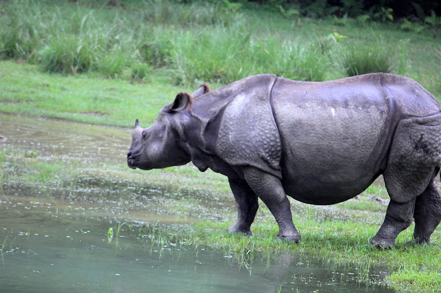
One horned Rhino (@Giri Photo 2016)
Langur Monkey
Peacocks (@Giri Photo 2016)
Sambar deer (@Giri Photo 2016)
Rhino horn (@Giri Photo 2016)
One of the four types of deer found in this park (@Giri Photo 2016)
Elephant Safari is popular here
This Rhino lost its horn-naturally? (@Giri Photo 2016)
Tortoise (@Giri Photo 2016)
Peacock
Wild boar (@Giri Photo 2016)
Crocodile
All photos taken by myself.

5/18/2015

Devastating Earthquake in Nepal: Feeling from Abroad


Shorter version of this article appeared in Casper Star Tribune yesterday.

It has been three weeks since Nepal was hit by a killer earthquake. The massive earthquake with a magnitude of 7.9 Richter scale occurred at 11:56 am (Friday night MT) on 25th of April, 2015 killing nearly 8500 (as of May 18) people and injuring more than twice as many. The epicenter of this quake was the Barpak village of Gorkha district, 80 km northwest of capital city Kathmandu and hypocenter was only 15 km deep. Hundreds of thousands of houses in Kathmandu and villages of surrounding districts were earthen unimaginably. The quake even shook the slopes of Mount Everest (the highest peak on earth) region triggering an avalanche that buried part of a base camp packed with national and foreign climbers preparing to make their summit attempts killing at least 18 people and injuring about 61. It even shrunk Mount Everest by one inch and raised Kathmandu by three feet as estimated by scientists using seismic interferometry. The quake has also impacted northern India, Tibet and Bangladesh. About 8 million people are affected by the disaster in Nepal.

(update: Another big quake hit Nepal on May 12 that has killed ~150)

How did I hear?
My phone and social media profiles started flooding with messages from families and friends asking my and my family’s safety, which I saw only after I woke up at around 5 am the same day in Laramie. I got so worried when I saw the pictures of the earthquake. Right after, I called my mom living ~200 km west of the epicenter. I also talked to my sisters. They were fine. My mom said that it was very hard shaking and for a long time. My dad was not at home since morning that day and tensions rose as repeated phone calls didn’t reach to him. He had gone to another town. Phone services were not reliable because of sudden rise in the call traffic and damage in the equipment. We were relieved when he came back home after few hours. I then started contacting my relatives and friends. The only thing that mattered the most at the beginning was to check my family was fine, be sad for those who passed away in the earthquake and pray for the people. For three to four nights everyone slept outdoors in an effort to stay safe from the aftershocks coming one after another. Nature didn’t do justice when rain and thunderstorms creating even more difficulty. More than 100 aftershocks of magnitude more than 4 made it the scariest. Getting right information from the ground using personal contacts, calls, emails and social media posts was very crucial. It was a very painful moment. Many of my friends were not able to know whether their family members were still alive for days. Even though my family and houses remain safe, houses of many of my friends got completely destroyed beyond repair, some friends lost their parents and siblings. My friends who also attended University of Wyoming and come from the village close to epicenter lost their houses completely. One of my friends who has been planning to complete his PhD in chemistry at the New Mexico State University in few months lost his father and uncle in his house at Sindupalchwok district, one of the hardest hit district, his mother was rescued live. My colleague lost her sister, sister-in-law and their child. There is still a lot of trauma going on for people.  Many of them are still outside, living in fields and tents. It is shocking and depressing to see how people have lost their lives, their houses, schools and mental peace. It has, at the same time, been difficult for the Nepali students at UW and their families in Laramie as they try to cope with the situation and work towards the end-of-semester.
Social media
The social media platform played very crucial role to get us updated and make connections to the loved ones in this difficult time. Communication to loved ones back home was not easy, especially during the early hours. The phone lines were so busy that it was hard to get through. Social media such as Facebook and twitter along with Skype and viber became vital to check on family and friends. Facebook’s “Safety Check” tool allowed anyone with a Facebook account to check how many friends are in an affected area, and see how many of them used the tool to confirm that they are safe. Google also launched a Person Finder tool in Nepali and English, which allowed people to search for and share information about missing persons. Web-based messaging tools like WhatsApp helped people circumvent crowded or disrupted phone lines. Even though I was far from home and not physically present there, I was able to closely follow every update from Wyoming.
In memory of the century old heritage sites
The Himalayan quake has damaged not only houses but also many monuments and temples listed in the UNESCO World Heritage Sites. Among them was the 9 story tower at the center of Kathmandu known as Dharahara. This tower was built in 1832. When I moved to Kathmandu in 1996 from countryside, it was this white tower standing above all the buildings. One could clearly see it. I had passed by this tower more than hundred times. We wished to climb this tower one day to have a 360 degree view of Kathmandu valley and surrounding mountains. In 2005, this tower was open to public. Then, I had climbed the narrow stairs of the tower with my mom while she was visiting me in Kathmandu. We went to the balcony at the 8th floor and watched Kathmandu for some time. This tower was not just a tower but had become a monument, an icon of Kathmandu and Nepal. Seeing it earthen brought tears into the eyes of millions. At first when I saw the photograph of the grounded tower, I could not believe it. I wished it was a bad dream. Unfortunately it was not. Also damaged were the century old temples in Basantapur, Patan, and Bhaktapur Durbar Squares, all listed in UNESCO heritage sites. I returned to Kathmandu after completing my PhD from the University of Wyoming last year and was staying close to the Patan Durbar Square area. Since then I have been to the heritage site several times and have taken hundreds of photographs. Now they are in photographs only. I know these places very well. The heritage and temples our ancestors built were the attraction for millions of visitors from across the globe are now limited to some photographs only.
Helpless
We knew that a big quake was coming but we were not sure when. The science is not able to make earthquake prediction yet unlike warnings for other natural disasters. There was very small effort to make houses quake resistant in Nepal. Most of houses in rural Nepal are made from bricks and stones joined by mud. These are the houses that were destroyed the most. Nepal is known for tall mountains. The great Himalaya range lies in the intersection of two giant tectonic plates of earth. Indian plate on south and Asian plate on the north side of Nepal. The Indian plate moves towards Asian plate and because of this movement, there is huge amount of energy stored inside the earth and when it releases this energy that part of the world is shaken almost every 80 years.
In a time of hardship, everyone wants to be with the loved ones to feel and share the pain. Unfortunately that was not possible for millions of Nepali living abroad. Being far from home and your loved ones when you could have helped had you been with them breaks our heart. Just seeing all damage on news and social media and not being able to help by only pray makes us feel helpless. Fortunately we Nepali are not alone at this moment. We are surrounded by supportive communities and friends around the world. University of Wyoming community and local Laramie community have been very supportive. Everyone has expressed concern and solidarity. I participated in a candlelight vigil prayer organized by Nepali community on Campus on Monday evening, 27th April for those affected by the quake. There is very little we can do but with the support from wonderful people around us, Nepali students attending the University of Wyoming, Laramie have collected some fund and relief materials, including medicines and school supplies to provide those to the victims when few of us fly to Nepal after the end of semester.
Now the life is slowly coming to normal. While we have lost peace of mind, we haven’t lost our hopes. We have to rebuild our heritage sites and houses. We rebuilt after the 1934 big quake by ourselves when our country was isolated and there was not much help from outside world. Good thing is this time we are not alone. We are fortunate to have helping hands around the world and we are well connected to them. Working together, we can for sure bounce back stronger. At this tragic pain also, smiles on Nepali faces has not been buried. People are helping each other, sharing food and shelter, which is a part of our culture. It has brought every Nepali together. Now, it’s time to build new Nepal. I will be going back to Nepal in two weeks and will see the devastation personally.

4/09/2014

खुट्टालाइ सास्ती मनलाइ मस्ति ।

निकुन्ज गेट पुग्न अगडि । 
अस्तिको शनिबार दिनभरी शिवपुरी निकुन्ज भित्र हिडेर बित्यो। त्यो हिडाइले यति खुट्टा दुखेछ की चार दिन पछि अहिले सम्म पनी पुरै ठीक भा'छैन । जंगल भित्र पहाडमा हिडेर, घुमेर, स्वस्छ हावा खाँदै करिब नौ घन्टा बिताउदा खुट्टा दुखाइ बिर्साउने गरेर "मन" भने आनन्दित भएछ।

काठ्मान्डु यसै त फोहर र प्रदुसित छ अली पहिले देखि नै। अझै पछिल्लो समय त सडक खनेर धुलई धुलो, गाडीको धुवा र मान्छे नई मान्छेको भिडले कोलाहल पूर्ण छ । एक महिना अगाडि अमेरिकाबाट आएकी एक जना प्रोफेसरले भनिन "सङठित अस्त बेस्त" काठ्मन्डु । केही समय हिंड्न पर्‍यो भने उकुस मुकुस हुन्छ। सास फेर्नै गार्हो हुने किसिमले । नाक छोपेर हिड्नु पर्छ, आँखा ढाकेर हिड्नु पर्छ । र पनि सास त फेर्नै पर्यो । यसले कति मान्छेको स्वास्थमा असार गरेको होला ? कति मान्छे यसकै कारणले मरे होलान् ? काठ्मान्डुमा भएको यस सम्बन्धी कुनै अनुसन्धान पढ्न पाएको छैन । प्रदुसित हावाकै कारणले उमेर करिब ५ बर्ष त कम हुन्छ होला (मेरो अनुमान मात्रै) । हप्ताको ६ दिन शहरको दुसित हावा खान परे पानी एक दिन त स्वछ हावा खाना पर्‍यो भनेर साथी प्रकाश र म शिवपुरी राष्ट्रिय निकुन्ज हाइकिङ गर्न निस्केको । दिनभरीको हाइकिङले मन आनन्दित भयो ।

बिहानको पेट पुजा 
हामी बुढानिलकन्ठ सम्म माइक्रोबस त्यसपछी करिब २ किलोमिटर हिडेर निकुन्ज गेट सम्म पुगिम् । हुनत गेट सम्म पानी माइक्रो जाने रहेछ, थाहा पाइएन। तर पनी त्यो ठाउमा बिहानै हिंड्न मजै आयो । गेट नजिकै को चिया पसलमा हल्का पेट पुजा गरेर रु १० को टिकेट काटेर निकुन्ज भित्र छिरिम। म नेपालको कुनै पनी राष्ट्रिय निकुन्ज भित्र छिरेको यो नई पहिलो पटक थियो । के लाग्यो सुरुमै भने, बरु रु १० को ठाउमा २० लिनु तर निकुन्ज को नक्सा सहितको जानकारी मुलक पर्चा दिनु पर्ने। कुनै जानकारी बेगर गएका हामी सुरुमा अलमलियौ कता कुन बाटो जाने भनेर । गेटमा बस्ने आर्मीलाई सोदेर अगाडि गयौ।


हाइकिङ ट्रेल टु गुम्बा 

गेट बाट पुर्ब तिर वा दाहिने तिरको बाटो समतियो । गाडी पानी गुडाउन मिल्ने त्यो बाटो गुम्बा सम्म पुग्ने रहेछ। गुम्बा बाट दक्षिण तिर काठ्मान्डु हेर्दा रमाइलो देखिने रहेछ। राष्ट्रिय निकुन्ज को बिचमा गुम्बा त्यो पानी ठुला ठुला कन्क्रिटका घरहरु सहितको, त्यो भौतिक सम्रचना बनाउन दिनु कत्तिको ठीक हो प्रकृति सम्रक्षन बिग्यहरुले भन्लान तर मलाई भने मन परेन ।  


धेरै हिड्ने मन नभए त्यहि गुम्बा बाट फर्के पनी हुने रहेछ । हामलाई अली हिंड्न रहर थ्यो । अनि शिबपुरीको टुप्पोमा पुग्ने रहर थ्यो सँग संगै बाघ्द्वार, जहाँ बाट बागमती सुरु हुन्छ, पनी हेर्ने धोको । त्यसैले माथी तिर लागिम ।  बाटोमा थरी थरीका रुख्।


बाघद्वार
बाघ द्वार बाट केही माथी पुगे पछि शिव पुरी बाबा को मन्दिर आउछ। हामी त्यहा पुग्दा एक जना बाबा ठुलो देक्चीमा पानी उमालेर चाउ चाउ का पोका फोडेर हाल्दै थे । संगै अरु २-४ जना, हाइकर हुनु पर्छ, थे । मन्दिर भनौ वा कुटी भनौमा सोदेको राती बास पनी पाइने रहेछ । प्रकाशजीले खाली रक्सिका बोटल देखेर के हो यस्तो चाला कुटीमा भन्थे । उक्त बाबाको ठाउ बाट सिदै पहाड टुप्पो तिर उक्लिय पछि शिबपुरी पिक पुगियो । मौसमले पनी साथ दिएको मान्नु पर्छ त्यो दिन् । घाम भएन बरु माथी पुगे पछि अली चिसो चिसो भयो । नजिकै अर्को कुटी रहेछ । एकजना महिला बाहिर भाडा माज्दै हुनुहुन्थ्यो । चिया खान पाईन्छ भनेर सोधेको हातको ईशाराले पाईन्छ भन्नु भयो । एक्छिनमा दुध वाला स्पेसल चिया आइपुग्यो बिस्कुटको पुरिया सङै । चिसो लागेको बेलामा तातो तातो मिठो चिया त्यो नी डाडाको टुप्पोमा खुब मजा आयो । त्यो पनी फोकटमा । पैसो लिन मान्नु भयेन ।

करिब २७०० मिटरको उचाइमा हामले चिया खाको ठाउ। 


करिब २७०० मिटरको उचाइमा । 


त्यस पछि भने ओरालई ओरालो तल झरियो। एकदम ओरालो बाटो । ढुङ्गा कुदेर बाटो बनाको रहेछ । तल उही गेट सम्म करिब ६ बजे आइपुग्दा थाकेर लखतरान परी सकेका थिम् । गाडी चद्ने सम्म जान नी गार्हो हुने गरि । काठमान्डु नजिकै प्रकृति अनुभब गर्न मिल्ने, सुरक्षित (हुनु पर्छ भन्ने मेरो अनुमान्), बाटो पनी राम्रो भा'को यो ठाउ बेला बेलामा आइरहनु पर्छ भन्ने लग्यो । २-४ वटा चराका फोटो पनी खिचेको छु, पछि कतै शेयर पक्कै गर्छु । हप्ताको कम्तिमा एक दिन भए पनी स्वस्क्छ हावा खाइयो, रमाइयो।

1/11/2013

पशुपतिका बादर

बादर भन्दा बित्तिकै मनिस संग जोडिएर केहि बिषय आइ हाल्छन। हाम्रो समाजमा चल्तीको उखान छ "बादरले न आफ्नो घर बनाउछ न अरुको बनाउन दिन्छ". त्यस्तै अर्को पनि प्रख्यात उखान छ "बादरको हातमा नरिवल". पक्कै पनि यी उखानहरु बादरको आनी बानि संग जोडिएका छन्। अर्को महत्वपुर्ण पाटो मान्छे र बादरको  विकासक्रममा नजिकको नातो पनि छ। मान्छे संग सम्बन्धित धेरै परिक्षणहरु पहिले बादरमा गरिन्छन। हुनत यसको आजभोली बिरोध हुदै गएको पनि छ। 

यसपाली केहि दिन अघि एकजना भाइको बुवाको अकस्मात निधन हुदा अन्तिम संस्कारको लागि पशुपति आर्यघाट पुगेको थिए। तेसै बेला पशुपतिका बादरको दर्सन नि पाइयो। हुनत यो भन्दा अगाडी नि धेरै पटक त्यो क्षेत्रमा बादर देखेको छु। सबै भन्दा पहिले अस्कल पढ्ने ताका होला। साथी साथी भएर घुम्दै थियौ। त्यॊ सेतो सेतो सानो डल्लो वाला मिठाइ बोकेर खादै गफ गर्दै पशुपति पारि बनकाली तिर घुम्दै थेम। एउटा बादरले पछाडी बाट दौडेर आएर मिठाइको पोको लुटेर भाग्यो। हामि त हेरेको हेरे। के नै गर्न सकिन्थ्यो र। 

यी बादरहरु मानव बस्तीको नजिक (बस्तीमै भने नि भयो) बस्छन। मान्छेले जस्तै खानेकुरा खान्छन। तिनको उचित व्यवस्थापन छैन। मैले देखेका करिब 20-30 बटा बादर (करिब एक घन्टाको अन्तरालमा) मध्ये धेरै जसो कुपोसन भएका जस्ता थिय। केहि रोगि थिए। छालाको रोग प्रस्टै देखिन्थ्यो। कोहि बल्ल बल्ल हिड्न सक्ने थिए, खुट्टामा घाउ भएको हुनु पर्छ। बच्चा बादर पनि थिए 2-4 वटा। ति पनि निन्याउरो अनुहार भएका। यिनलाई आवस्यक खानेकुरा कसले देवोस। रोग लाग्दा कसले उपचार गर्देओस। 

त्यस्तै  बनकालीको जंगलमा धेरै मृगहरु नि देखियो यसपाली। तिनको पनि जनसंख्या यति धेरै बढेको छ रे कि खाने कुरो केहि भेट्टाउनन। जंगल को भुइमा एउटो हरियो भन्ने केहि थिएन, माटै माटो मात्र। केहि वर्ष अगाडी लगेर छोडिएका यी मृगको जनसंख्या बढेर उचित व्यवस्थापन भएन रे। अरु कुनै जंगल मा लगेर छोडीदिनु नि। 


सबै फोटो मा आफैले खिचेको हु। 

7/01/2012

जुत्ता भित्र हिउ छिर्यो।


समरमा हिउ देख्ने वा खेल्ने हो भने वायोमिंग राज्य घुमे हुन्छ. करिब एक महिना पहिले भरियाको काम गर्न टेटोन गाको बेलामा paint brush canyon कों हो यहि ठाउँ बाट फर्किन पर्या थ्यो। करिब 8000 फीट अग्लो छ यहा. योजना 12000 सम्म जाने थियो तर यो हिउ ले गर्दा फर्किन पर्यो। एक किसिमले त ठिकै भयो, हिड्न परेन। फर्किने परे सी के गर्ने भन्दै माथि तिर हेर्दै गरेको एउटा आइडिया आयो। उफ्रेर फोटो खिच्ने। क्यामेराले मिलाएर खिच्यो भने निकै माथि उफ्रे जस्तो फोटो निस्किन्छ। अनि झ्याम खिचियो यो माथिको फोटो। उफ्रिन त उफ्रे तर जुत्ता भित्र हिउ पस्यो। क्या झ्याउ लाग्ने चिसो। 

6/24/2012

Old Faithful Geyser Eruption Live

Look at this video I captured during our recent trip to Yellowstone NP, WY. This Old Faithful is the most predictable geographical feature on earth. Water erupts almost every 91 minutes. Last year we missed it. When reached this place, it had just erupted and we didn't have time to wait another one and half hour. This year we were lucky. We just had to wait ~15min. Details of this phenomenon can be found in wikipedia.

9/06/2011

पहेलोढुङे राष्ट्रिय निकुन्ज (Yellostone NP) को यात्रा

पोहर साल देखि नै हो एक पटक त जानै पर्छ भन्ने लागेको। प्राबिधिक कारण भनेर अन्तिम् समयमा स्थगित गर्नु परेको थियो। अमेरिकाको हेर्नै पर्ने मध्यको एउटा स्थान हो यो yellostone national park । अझ यता वायोमिङमा बस्न थाले पछि त उही राज्यमा पर्ने निकुन्ज त हेर्नै झन चासो भयो। नजिक हुनाको कारण। नजिक भन्नाले करिब नौ घन्टाको दुरी गाडिमा। अमिरिकी राष्ट्रपति Grant ले सन् १८७२ मा यो राष्ट्रिय निकुन्ज घोषणा गरेका थिए। यो नै विश्वमै पहिलो राश्ट्रिय निकुन्ज हो। यो निकुन्ज अमेरिकाको वायोमिङमा छ, र अलि अलि आइडाहो र मोन्टाना राज्यमा फैलिएको छ।  ८९८३ बर्ग किलो मिटरमा फैलिएको यो निकुन्जमा बिभिन्न किसिमका जंगली जनावर खासगरी ग्रिज्ली भालु, बाइसन (भैसी पनि भन्छन् खैरेले यसलाइ, तर हाम्रो तिरको जस्तो हैन), बिभिन्न किसिमका म्रिगहरु, कालो भालु, ओल्फ आदि र geotharmal features जस्तै hot spring र geysers पाइन्छन्। प्रत्यक्ष जंगली ठाउमै यस्ता जनावर हेर्ने लालच के। सुश्माले आफ्नो कोर्समा पढेकी रैछन अनि यो निकुन्ज हेर्ने सपना थियो रे। यसपाली त्यो सपना पुरा भयो।

पुरानो मायान पात्रोमा बिश्वासगर्नेहरुको लागि त सन् २०१२ को डिसेम्बरमा प्रलय आएर प्रिथ्बी ध्वस्त हुन्छ भन्ने हल्ला सुन्नु भा होला नि। हो त्यो प्रलय यहि Yellostone बाटै सुरु हुन्छ रे।  आउनुस यसपाली त्यहि ठाउको भ्रमण् गरौ। 

कुन बाटो जाने र कसरी घुम्ने? : यो निकुन्ज जान हामी बस्ने ठाउबाट बिभिन्न बाटा छन्। हाम्ले के बिचार गरिम भने जादा एकातिर बाट जाने अनी फर्किदा अर्को तिर बाट। दुरी र समयको हिसाबले खासै फरक नपर्ने। तर द्रिश्य फरक फरक हेर्न पाइने। हाम्रो टोलिमा म, सुष्मा, शशी सर्, भाउजु, एन्जिला एउटा गाडिमा अनी ब्राड, लिङ र लिङको साथि अर्को गाडिमा थिम्। बिहान करिब पांच बाजे सुरु भयो हाम्रो यात्रा। अंरिकामा बस्दा कहीले नदेखिने सुर्योदय त्यो दिन देखियो। कहीले उठ्ने भएपो ब्यानै देखिन्थ्यो सुर्य उदाको। सदै म उठिसक्दा सुर्य पहिले नै निस्की सकेका हुन्छन्। I-80 मा पश्चिमतिर गाडी चलाउदै जादा बिहानी पखको द्रिश्य रमाइलो थियो। Rock spring सम्म पुगेर त्यहा बाट उत्तर तिर लाग्ने। अनी फर्किदा Cody हुँदै Rawlings भएर Laramie आउने Route बन्यो। हेर्नुस तलको गूगल Map।   


View Larger Map

दुई रात् तीन दिनको यात्रा। समर नै पर्यटक जाने peak सिजन। होटेलमा हैन की camping गर्ने योजना गर्या थिम्। यसमा २ वटा कारण थे। पहिलो त होटेलमा बस्दा महँगो पर्ने। गरीब Graduate स्टुडेन्टलाई खर्च थेग्न गार्हो। पुरै economic प्लान। दोश्रो camping गर्ने रहर र तेस्को मजा। खाने कुरा Laramie को वालमार्ट बाट किनेर cooler मा हालियो। गाडी पनि आफ्नै, टेन्ट पोहोर किनेको। भन्दा खेरी ठुलो खर्च भनेको गाडीको तेल मात्रै। दुई रात् टेन्ट भित्र सुत्ने र तेश्रो रात् घरमै आइपुग्ने।  यति समयमा हेर्न पार्ने मुख्य मुख्य स्थान हेर्न सकिन्छ भन्ने हिसाबले योजना बनाको थे। 

पहिलो दिन रमाइलो ड्राइभिङ : करिब २०० माइल् तीन घन्टामा ड्राइभ गरे पछि हाम्रो गाडीले ड्राइभर फेर्यो। अब शशी सरको पालो। म अगाडिको प्यासेन्जर सीट्मा। फोटो खिच्ने मेरो काम्। Rock Spring बाट Jackson जाने बाटो (US -१९१) उत्तर तिर लागि सके पछि, पेट्मा मुसा दौड्न थाले। नजिकै जुन पिक्निक स्थल भेटिन्छ तेही लन्च खाने सल्लाह भयो। सुष्मा र बसन्ता भाउजुले अघिल्लो दिन दिन्भर मिहिनेत गरेर बनाको म:म खाइयो र बाटो लागियो।  
Mo:Mo break. Heading north to YSNP.

to be continued...............

8/04/2011

Wild Flowers in Greater Yellowstone National Park Area

These are the photos from Greater Yellowstone National Park Area which includes Grand Teton and Yellowstone National Parks. I don't know the names of these wild flowers but they look very beautiful. If you know the names, please name them on the comment box. These were taken during our recent trip to the area from July 24th to 26th, 2011. Click on the photo to see the larger version.


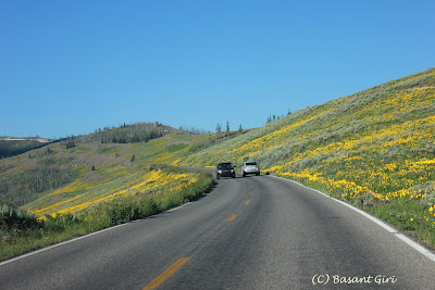
All above photos are from the north tip of Jackson Lake, Grand Teton NP. And the photos below are seen while driving down from Mammoth to Canyon area. I enjoyed the scenic road driving.